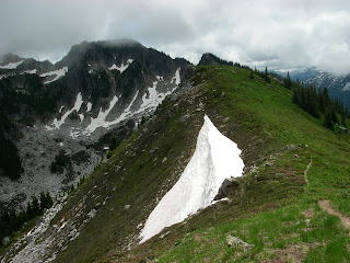
A generation of hikers have never seen what lies beyond milepost 12.0 of the 23 mile-long Suiattle River Road – and many who have seen it, have missed out on all the Suiattle region has to offer since a series of washouts in 2003, 2006, and 2007 have steadily gnawed away at the road. An important portal to the west side of the Glacier Peak Wilderness Area, the Suiattle River Road, which runs along the Suiattle River northwest of Darrington, has been missed by many Northwesterners. Nearly a decade later, the road is still not repaired. To some, this blog post is a reminder to what we’ve been missing – to others, it’s a primer.
 |
| Sulphur Mtn. fire lookout site and the true summit beyond |
Initially a Native American route used for hunting and trading across the Glacier Peak region, then later a logging railroad grade, the present-day Suiattle Road was built in phases, completed around 1931. Generations of people have enjoyed the wild places of the Suiattle River, including renowned guidebook author and conservationist Harvey Manning, who received his advocacy epiphany high on the flanks of the mountains above the Suiattle River (see pg 62 of linked article).
Trails wind through old growth forests, popping out at high mountain lakes and meadow- laden ridges that lead to glaciers and thick walls of volcanic ash deposited by Glacier Peak, Washington’s most remote volcano. Destinations accessed by the Suiattle River Road include the Pacific Crest Trail (PCT), the Suiattle River Trail, Miner’s Ridge Fire Lookout, the Milk Creek trail, Lime Ridge, Sulphur Mountain trail, Bath Lakes High Route, Sulphur Hot Springs, Green Mountain Lookout, Huckleberry Mountain trail, Downey Creek trail, the Ptarmigan Traverse and Dome Peak. Popular drive-in campgrounds near the roads end include Sulphur Creek, Buck Creek and Downey Creek.
On October 21, 2003, nearly 10 inches of rain fell in the Suiattle watershed. Floodwaters swept away multiple bridges, including the 265 foot-long Skyline Bridge, as well as a steel -beam bridge that led to the Milk Creek trail, and Boundary Bridge, the automobile bridge that spanned the river at Forest Road 25.
The Suiattle Road suffered a washout at milepost 14.4, and further down the road, the river scoured the bank away from the foot of the Downey Creek Bridge Sulphur Creek Bridge
Over the years, undaunted hikers constructed various styles of ladders to clamber onto the Downey Creek Bridge and beyond.
In 2006, more floods added damage to the ailing Suiattle Road. This flood was especially devastating, because now the road ends at milepost 12, making each trailhead that much farther away.
And so time goes by. In 2007, milepost 6.0 was severely damaged and the Forest Service built a temporary re-route. The Boundary Bridge was repaired in 2010, and a new bridge spanning the Suiattle at the PCT was completed in 2011, marking the official re-opening of the PCT on the west side of Glacier Peak , administratively closed since 2003.
So – What’s taking so long to fix the road? Stay tuned!
In the meantime, pull out your Green Trails maps and peruse 112 Glacier Peak, 79 Snowking, 80 Cascade Pass, and 144 Benchmark….

6 comments:
What IS taking so long, Kim -- do tell!
I road my bicycle down the Suiattle Road last summer. It was nice to see the old trailhead signs again. I felt a real sense of loss when we rode through the empty campgrounds that were always full. This road is such an important road connecting many hiking trails & campgrounds. It is a beautiful scenic drive allowing everyone the opportunity to lush green forest & views of the river. It is VERY missed by the public that once used it!
Wilderness Watch...blame it on them.
I hope folks take the time to open the links provided in the article, particularly the one to an article by Karen Sykes, and one by T.D. Wood, which details some issues regarding trail damage. Both articles include neat-o photos of flood damage.
Check back for another blog post soon.
In the meantime, get on your bicycle. It's two miles to the huckleberry mtn trailhead. The Buck creek campground is about three miles in, if you like Dosewallips-style developed campgrounds without the cars. The Downey Creek trail is 8 miles in. It's 10 flat miles to the end of the road; a leisurely ~2 hour ride. Green Mountain is a little more challenging; turn off at mile 7 up the green mountain road, and then grunt up a 2000' granny-gear climb to the old trailhead, do your Green mtn trail hike, and finish it up with a 45-minute downhill tear back to your car. More work than it used to be, but how many people can say they hiked green mtn on a nice summer day and saw nobody else? Enjoy it while it lasts, rather than waiting around for a motorized valley.
I'll never bike the Green Mtn Road. It's too difficult for me, especially with backpacking gear.
I did Green Mtn a few summers ago via the lower trail that was abandoned when the Green Mtn Road was built (1958, I think). The original trail started at Downey Creek. We followed it up to where it popped out onto the road a short way from the current trailhead. I enjoy old trails. Tons of old growth logs down, of course. We lost the tread here and there, but overall, it was in good conditiong (no water sources to erode the slope).
Though picking along the old trail was a cool thing to do, I don't want to use the old trail to visit Green Mountain all the time. I'll be happy when the road is fixed. I promised my sisters I'd take them up some day. The road being washed out is a deal-breaker for them.
Post a Comment