Wednesday, January 25, 2012

A hiker’s orientation to the Suiattle River region

By Kim Brown, Public Lands Intern


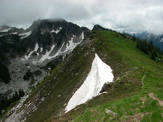
Sulphur Mtn. fire lookout site and the true summit beyond
 A generation of hikers have never seen what lies beyond milepost 12.0 of the 23 mile-long Suiattle River Road – and many who have seen it, have missed out on all the Suiattle region has to offer since a series of washouts in 2003, 2006, and 2007 have steadily gnawed away at the road. An important portal to the west side of the Glacier Peak Wilderness Area, the Suiattle River Road, which runs along the Suiattle River northwest of Darrington, has been missed by many Northwesterners. Nearly a decade later, the road is still not repaired. To some, this blog post is a reminder to what we’ve been missing – to others, it’s a primer.
Initially a Native American route used for hunting and trading across the Glacier Peak region, then later a logging railroad grade, the present-day Suiattle Road was built in phases, completed around 1931. Generations of people have enjoyed the wild places of the Suiattle River, including renowned guidebook author and conservationist Harvey Manning, who received his advocacy epiphany high on the flanks of the mountains above the Suiattle River (see pg 62 of linked article).
Trails wind through old growth forests, popping out at high mountain lakes and meadow- laden ridges that lead to glaciers and thick walls of volcanic ash deposited by Glacier Peak, Washington’s most remote volcano. Destinations accessed by the Suiattle River Road include the Pacific Crest Trail (PCT), the Suiattle River Trail, Miner’s Ridge Fire Lookout, the Milk Creek trail, Lime Ridge, Sulphur Mountain trail, Bath Lakes High Route, Sulphur Hot Springs, Green Mountain Lookout, Huckleberry Mountain trail, Downey Creek trail, the Ptarmigan Traverse and Dome Peak. Popular drive-in campgrounds near the roads end include Sulphur Creek, Buck Creek and Downey Creek.
On October 21, 2003, nearly 10 inches of rain fell in the Suiattle watershed. Floodwaters swept away multiple bridges, including the 265 foot-long Skyline Bridge, as well as a steel -beam bridge that led to the Milk Creek trail, and Boundary Bridge, the automobile bridge that spanned the river at Forest Road 25.
The Suiattle Road suffered a washout at milepost 14.4, and further down the road, the river scoured the bank away from the foot of the Downey Creek Bridge. The Sulphur Creek Bridge at milepost 22.9 was also damaged. A helicopter rescued hikers caught on the wrong side of the damage, and later the Forest Service constructed a temporary ramp to get the trapped vehicle across Downey Creek.
Over the years, undaunted hikers constructed various styles of ladders to clamber onto the Downey Creek Bridge and beyond.
In 2006, more floods added damage to the ailing Suiattle Road. This flood was especially devastating, because now the road ends at milepost 12, making each trailhead that much farther away.
And so time goes by. In 2007, milepost 6.0 was severely damaged and the Forest Service built a temporary re-route. The Boundary Bridge was repaired in 2010, and a new bridge spanning the Suiattle at the PCT was completed in 2011, marking the official re-opening of the PCT on the west side of Glacier Peak, administratively closed since 2003.
So – What’s taking so long to fix the road? Stay tuned!
In the meantime, pull out your Green Trails maps and peruse 112 Glacier Peak, 79 Snowking, 80 Cascade Pass, and 144 Benchmark….


Monday, January 9, 2012

Ross Lake National Rec Area's new Plan


By Kim Brown, Public Lands Intern

The turquoise of Ross Lake & green mosses and trees
Here’s more information to impress your friends with:  North Cascades National Park (NCNP) and Ross Lake National Recreation Area (Ross Lake NRA) are both managed by the National Parks Service (NPS), but the Park and the NRA are managed for different objectives.
The primary purpose of a NRA is to provide for outdoor recreation, rather than the focus of the National Park System on conservation and historic preservation. The management plan of an NRA is consistent with the management plan of its land manager, in this case, Ross Lake NRA is managed by North Cascades National Park. 
OK now for the business at hand: It's time to update the management guidance for Ross Lake NRA, which historically has been a part of the North Cascades National Park General Management Plan (GMP). The separate Ross Lake GMP will guide management of the Ross Lake NRA for the next 15-20 years.

NPS has completed the Environmental Impact Statement detailing the various Alternative management plans for Ross Lake NRA, the Preferred plan being Alternative B (see Chapter 4, Alternatives, at bottom of the page of this link ). The public comment period ends January 17.
Since the last GMP was implemented in 1988, campgrounds have been severely damaged by storms and visitation has increased, so a facelift is needed for Ross NRA.
Alternative B allows for the management of future storm damage with as little interruption to recreation as possible.  Visitors may have more front-country and better backcountry trails, more front- and backcountry campsites, better campground amenities, more educational opportunities and new viewpoints. Sport climbing in the gorge between Newhalem and Diablo will be better managed through four Climbing Management Areas.
Wild places will be kept wild, continued efforts for the preservation of grizzly bear habitat, and nearly 5,000 acres of previously proposed Wilderness at Big Beaver Natural Preservation Area and Thunder Creek will be officially added to the Stephen Mather Wilderness Area. Goodell and Newhalem Creeks and a portion of the Skagit will be recommended for Wild & Scenic River status.
With the new GMP, we may see an on-line reservation system for backpacking permits, which will benefit National Park visitors as well.  You’ll still have to pick up the permits in person, however. The last mile of the road to Thornton Lakes (within the Wilderness boundary), will be officially decommissioned and a better trailhead built.
A second water taxi for Ross Lake Resort will better serve backpackers and resort visitors, its footprint on the lake being tempered by more restrictions on types of motors allowed on the lake.
Currently a National Forest Byway and a Washington State Scenic Highway, the North Cascades Highway will be nominated as a designated National Scenic Byway.
An immediate change will be the name -- to better associate the Ross Lake NRA with North Cascades National Park, it will be re-named “North Cascades National Recreation Area.”
Ross Lake, the Skagit River, the Seattle City Light dams and the North Cascades Highway corridor compose a special destination for recreationists, and the proposed Alternative B for the GMP will continue to provide a range of opportunities at the re-named North Cascades NRA, while providing an appropriate gateway to the grandeur of North Cascades National Park.


Friday, January 6, 2012

State DNR to kick off recreation planning for the Snoqualmie corridor


The Washington State Department of Natural Resources (DNR) is planning for the future of recreation on 53,000 acres of state trust lands, natural areas, and other lands managed by DNR along the Snoqualmie corridor in eastern King County. DNR is inviting the public to an open house on January 18 in the City of Snoqualmie to kick off the planning process and get feedback from citizens.

Who: DNR Recreation Program

What: Snoqualmie Corridor Recreation Plan Open House

When: 7 to 9 p.m., Wednesday, January 18, 2012

Where: Snoqualmie Middle School, Commons Room
9200 Railroad Ave. S.E.
Snoqualmie, WA 98065
Directions

Why: The Snoqualmie corridor, located in eastern King County,
offers tremendous opportunities for outdoor recreation near the ever-growing Seattle metropolitan area. In the past 20 years, DNR has increased the amount of land it manages in the corridor. Some are state trust lands-working forests; other lands form the largest network of natural areas in the state. As a major provider of recreation opportunities in this landscape, DNR understands the need for a comprehensive and strategic approach to recreation management.

Meeting Format: The first part of the open house will be a brief presentation by DNR staff on the planning process. Following the introductory presentation, the public will have the opportunity to share their thoughts and ideas about recreation in a "listening station" format.

Snoqualmie corridor planning area
The 53,000-acre planning area includes two newer DNR-managed properties:
the Raging River State Forest, purchased in 2009 to replace state trust lands previously transferred out of trust status, and the Middle Fork Snoqualmie Natural Resources Conservation Area (NRCA), which was designated in 2009 by Peter Goldmark, Commissioner of Public Lands.

While the main focus of this effort is to develop recreation management plans for Raging River and Middle Fork Snoqualmie, the planning process also involves DNR-managed lands with existing management plans, such as Tiger Mountain State Forest, West Tiger Mountain NRCA, Mount Si NRCA, and Rattlesnake Mountain Scenic Area.

The corridor also includes recreation lands managed by federal, state, and local entities. Although planning will not include activities on those lands, this strategic planning process will look at ways to improve coordination with managers of many of these lands.

During the last few months, DNR has been gathering information related to recreation in the Snoqualmie corridor. This information will help to guide planning for future recreation opportunities. In addition to the open house, the public will have numerous other ways to be involved throughout this process.

More information about the Snoqualmie Corridor Recreation Plan.